Sights, Hikes, and Food!
The Highlands area is filled with beauty and opportunities for fun. We created this page so our visiting family and friends won't miss out on anything Highlands has to offer.
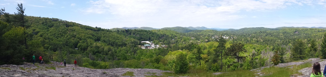
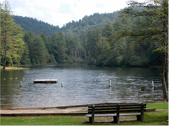
Highlands Visitor Center
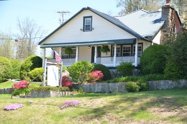
Highlands Visitor Center
|
|
Across the street from the Highlands Post Office at the intersection of Dillard Road and Franklin Road, the Highlands Visitor Center is also close to Two Holt. Drop by and pick up maps and brochures for more information about the area. Chat with those working at the center and you may discover other entries to add to your "Must See and Do" list!
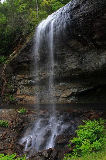
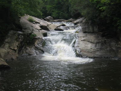
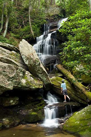
Glen Falls
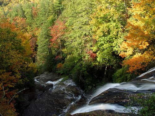
This is only a 1.1 mile hike, BUT the elevation changes by 430 feet...easier going down; it's a steep climb coming up! You really get two falls in one. It forms two distinct tiers of falls totaling
over 200' in height, each with an entirely different look and feel. Makes for an excellent half-day hike, and it's a great trail for families and older children. Here's an excellent website for detailed hike directions and photographs of what you will see (such as the one above): http://www.ncwaterfalls.com/glen1
Directions: From the corner of Main Street and NC 106 in Highlands, follow NC 106 West for 1.6 miles. Turn left at the sign for the Glen Falls Scenic Area, then IMMEDIATELY right onto the gravel road. The road crosses a bridge and ends after 1 mile in a small cul-de-sac. Park here.
Blue Valley
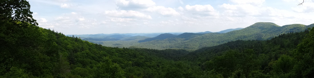
Coming up to Highlands from Dillard, Georgia (NC 106), you will see an overlook area to the right called Blue Valley Overlook. Drive right up, park, and enjoy the view. Blue Valley gets its name from the natural haze that shades the valley and its surrounding carpet of mountains. The gentle hills seem to roll on forever and, looking from the Blue Valley Overlook, you get the feeling that the whole world is made of mountains.
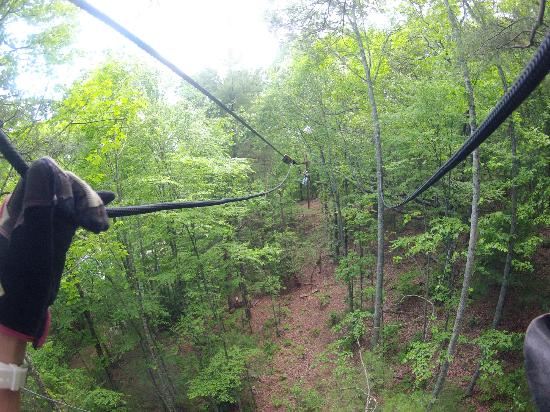
Highlands Aerial Park
|
|
|
Highlands Aerial Park provides some of the newest fun in our area. I haven't been yet, but I do plan to go! There are zipline activities for adults and for children. Contact information is provided below for a more detailed description of activities and pricing. Enjoy!
Physical Address: 9625 Dillard Rd., Scaly Mountain, NC 28775
Phone: (828) 526-8773
Website: www.highlandscanopytour
Physical Address: 9625 Dillard Rd., Scaly Mountain, NC 28775
Phone: (828) 526-8773
Website: www.highlandscanopytour
Sunset Rock
Sunset Rock is an ideal choice for a leisurely hike in the Highlands area. A short 1/2 hour walk, approximately 0.6 miles one way, leads to a natural cliff side amphitheater where slabs of granite provide front row seats. Beautiful sunsets can be seen over Highlands and Brushy Face Mountain to the west and the vista of Horse Cove to the east (Sunrise Rock) is worth the walk at any time of day. You can also drive right up to Sunset Rock if you don't feel like an easy hike.
To locate the trail take Hickory Hill Road (Two Holt's location) to Mirror Lake Drive. Turn right and go over Mirror Lake bridge all the way to the stop sign. Turn left on Highway 64. Drive straight through town on Main Street. Watch carefully for Highlands Nature Center on the left and a gravel parking area across the street marked Sunset Rock. You can park and walk or drive right up the little road beside the parking area.
To locate the trail take Hickory Hill Road (Two Holt's location) to Mirror Lake Drive. Turn right and go over Mirror Lake bridge all the way to the stop sign. Turn left on Highway 64. Drive straight through town on Main Street. Watch carefully for Highlands Nature Center on the left and a gravel parking area across the street marked Sunset Rock. You can park and walk or drive right up the little road beside the parking area.
Highlands Botanical Gardens
Directly across the street from the Sunset Rock parking area is the Highlands Botanical Garden which was established in 1962 as a refuge for the diverse flora of the Southern Appalachians. Nearly 500 species of mosses, ferns, wildflowers, shrubs and trees flourish in natural forest, wetlands and old-growth plant communities connected by a series of trails and boardwalks. The Botanical Garden is free and open to the public year-round from sunrise to sunset.
Bridal Veil Falls
Bridal Veil Falls is a 120-foot fall that in times of little or no rain can be a mere trickle of water from the rocks above. By no means is this fall a raging river of water even during times of high precipitation.
Originally, Highway 64 passed directly under the falls but eventually was rerouted to pass in front of Bridal Veil Falls. Drivers can still travel behind the falls today.
To get to Bridal Veil Falls, take Hickory Hill Road (Two Holt's location) to Mirror Lake Drive. Turn right and go over Mirror Lake bridge all the way to the stop sign. Turn right on Highway 64. Bridal Veil Falls will be a mile or so down the road on the right.
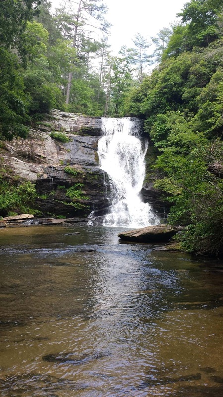
Dry Falls
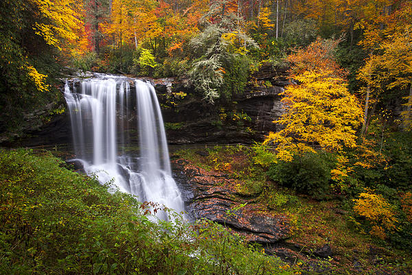
Continue on down Highway 64 one mile past Bridal Veil Falls and you will see the entrance to Dry Falls on the left.
Dry Falls is a very popular fall because it is not only beautiful but also easy to access. The trail from the parking lot is only a few hundred feet in length, running alongside the Cullasaja River. As you walk down the trail, you may begin to feel the spray and the path will become damp and slippery. Handrails follow alongside the trail to guide you behind, under, and to the other side of the falls.
At the top of the falls, the water free falls about 40 feet to the rocks below where it cascades over the rocks for another 40 feet. When walking "under" the falls, you are about 30 feet below the top of the falls and can generally feel a little spray from the falls.
Cliffside Lake
Cliffside Lake is a great place to take your family for a day of swimming, hiking trails, and trout fishing. There are bathrooms and showers available. Cliffside Lake is regularly stocked with Brook, Brown, and Rainbow trout and your chances of catching your limit of 7 are pretty good.
Coming from Highlands, take US Hwy 64 West (Franklin Road). The entrance will be past Dry Falls on your right. Follow the paved road for approximately one mile until you reach the gate and a pay station. There is a $4.00 fee to park and picnic/fish/swim/hike/etc. Take the first right through the gate to access the first parking area for swimming, bathhouse, and lake access.
Coming from Highlands, take US Hwy 64 West (Franklin Road). The entrance will be past Dry Falls on your right. Follow the paved road for approximately one mile until you reach the gate and a pay station. There is a $4.00 fee to park and picnic/fish/swim/hike/etc. Take the first right through the gate to access the first parking area for swimming, bathhouse, and lake access.
Bust Your Butt Falls
Bust Your Butt Falls is one of several waterfalls near Highlands and Franklin and has become a favorite spot for locals to come cool off. If you like an adventurous thrill, then climb up the rock face at the bottom of the pool (you'll see a rope tied off to a tree) to the ledge above it. This is, of course, at your own risk. Make sure the water level is at an acceptable height and jump as far out from the ledge as possible. People have been climbing even further up on the cliff side to jump from higher up, but it is not recommended at all. These falls can be very dangerous when played on. There are "holes" in each tier of the falls that you can be trapped in. In 2009 there was a fatality when a man got his foot caught between rocks and drowned. Stay off the rocks and keep to the large pool.
Right next to Highway 64 as you go from Highlands to Franklin. There are no signs and, if you're not paying attention, you will miss it. You will come up on an opening where you will see the river next to the road and many large boulders and rocks. There is a place to pull off on the left, but be careful, you should drive past and turn around to get to the pull over.
Right next to Highway 64 as you go from Highlands to Franklin. There are no signs and, if you're not paying attention, you will miss it. You will come up on an opening where you will see the river next to the road and many large boulders and rocks. There is a place to pull off on the left, but be careful, you should drive past and turn around to get to the pull over.
Cullasaja Gorge
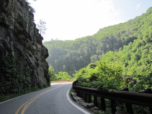
The Cullasaja River Gorge offers a spectacular scenic drive (Highway 64) between the towns of Franklin and Highlands, North Carolina. Cullasaja Falls, a 250-foot waterfall, can be seen from the road.
Cullasaja means "honey locust place" in the Cherokee language. The gorge is part of the trail followed by Spanish explorer Hernando DeSoto in 1540.
The Eastern Continental Divide runs through the town of Highlands. In many places along this divide, waters run eastward to the Atlantic only a few feet from waters headed westward toward the Gulf of Mexico. Water in the Cullasaja River is bound for the Gulf of Mexico.
Whiteside Mountain
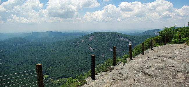
Midway between Cashiers (pronounce it "Cashers" or your pronunciation of "Casheers" will be a dead give-away that you're a tourist)and Highlands on Hwy 64, you will see a large Green State Sign showing you the way to this majestic mountain which is considered to be the oldest mountain in the United States. Some even claim it is the oldest mountain in the world! Just west of the Jackson/Macon County line, turn onto Whiteside Mountain Road (SR #1690). Go 1 mile to the well-marked parking area on the left. You will notice that this is a fee area with the National Forest Service. The charge is $2.0O. There is also a restroom facility located in the parking area.
Perhaps one of the best trails in the area for a panoramic view is the Whiteside Mountain Trail. Beautiful views of the surrounding area can be seen from vantage points all along the trail. The summit of the mountain reaches an elevation of almost 4900 feet. Rock outcrops are numerous.
The trail is a 2-mile loop that goes around the back or north side of the mountain and then along the ridge. The total climb is approximately 500 feet. The trail can be walked in an hour but you will want to allow plenty of time to take in the vistas.
Brooks Creek Waterfall
This is a waterfall that you can drive right up to if you don't want to hike. From downtown Highlands, take NC Hwy 28 from the stop light at Hwy 64 in the center of town. Drive 2 miles and turn right on Clear Creek Road. Drive 1.2 miles on Clear Creek and turn right on the unmarked gravel road FR367. It's the 1st right after a hairpin turn on Clear Creek. Drive down this gravel road 2.3 miles and the waterfall is on the right. While you can see it from the road, there is a small path you can take for a better view.
Secret Falls
You can read all about our hike to Secret Falls here. Be sure to pack a swimsuit because there's a great swimming hole at the base of the falls. In fact, pack a lunch and spend the day! Here are the directions for getting there:
From Main Street in Highlands at the intersection of Highways 28 and 64, drive south on NC 28 for 4.1 miles to Wilson Gap and turn left on Rich Gap Road (the road to Highlands landfill). Drive 0.6 miles and turn right on Forest Service road FR45670 which is unpaved. Drive approximately 1.75 miles to the Big Shoals parking area on the right. The trail will be directly in front of your parked car. It starts as an old road bed, but quickly turns into a footpath. Stay on the footpath until you cross two streams. The trail will turn left shortly after the second stream. (Look for blue marks on the trees along the way to ensure you're on the path!) As you approach the falls, the trail narrows and splits. The main trail will continue straight to the top of the falls and a rough, steep trail descends to the right to the base of the falls.
From Main Street in Highlands at the intersection of Highways 28 and 64, drive south on NC 28 for 4.1 miles to Wilson Gap and turn left on Rich Gap Road (the road to Highlands landfill). Drive 0.6 miles and turn right on Forest Service road FR45670 which is unpaved. Drive approximately 1.75 miles to the Big Shoals parking area on the right. The trail will be directly in front of your parked car. It starts as an old road bed, but quickly turns into a footpath. Stay on the footpath until you cross two streams. The trail will turn left shortly after the second stream. (Look for blue marks on the trees along the way to ensure you're on the path!) As you approach the falls, the trail narrows and splits. The main trail will continue straight to the top of the falls and a rough, steep trail descends to the right to the base of the falls.
Local Grocery Stores & Restaurants
We usually buy groceries at Bryson's located in Highlands Plaza. The plaza also has a Subway, Golden China Restaurant, and one of the best Mexican restaurants we've ever enjoyed--El Azteca. Each Saturday morning during the summer there is a Farmer's Market set up in the parking lot.
Driving directions to Highlands Plaza from Two Holt:
1. Head northeast on Hickory Hill Rd toward Mirror Lake Rd.
2. Turn right onto Mirror Lake Rd
3. Turn left onto Franklin Rd
4. Continue to first traffic light (Post Office will be on right)
5. Turn right at the traffic light.
6. Pass Spring Street on the left and the next paved entrance on the left will be the entrance to Highlands Plaza.
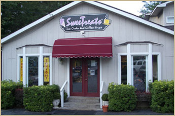
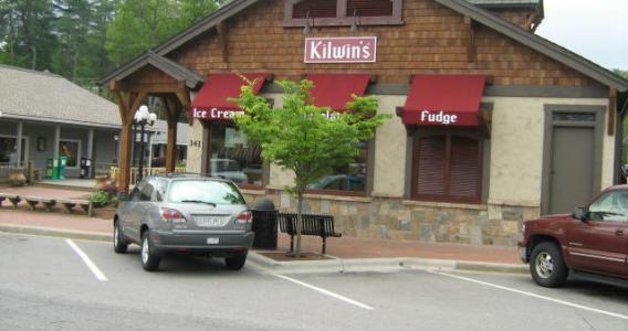
For those with a sweet tooth...
For more information and menu go here: http://www.sweetreats.com/
|
For more information: https://www.kilwins.com/highlands
|

|
Pictured above are three sure-to-please opportunities to satisfy any sweet tooth cravings!
Sweet Treats actually has two locations...one is on Main Street and has a deli, but the one to be sure to visit is the original location. From Two Holt, drive down Main Street and turn left at 64 East towards Cashiers. Sweet Treats will be in Mountain Brook Center on the right. Enjoy your ice cream while feeding and watching the trout in the stream right below the deck. You may even see my sunglass clip-ons which fell straight down to an inaccessible creek bank below!
The ice cream and fudge at Kilwin's is always a treat. You will find Kilwin's on Main Street in Town Square. Outside tables in the square are a favorite destination when local musicians are playing (usually weekend nights).
Chill is a newer sweet shop in Highlands. Kids love to choose their own soft-serve yogurt and add any of dozens of toppings to complete their selection. Your final product will be weighed and you pay by the ounce. From Two Holt, drive down Main Street and turn left on 64 East. Chill is on the immediate left. It's an easy walk if you find yourself walking on Main Street. (By the way, public restrooms are just past Chill and up a paved hill.)
Other Eating Places
Highlands is known for its fine dining restaurants, but sometimes you just want more casual and less expensive dining. Here are a few of our favorites, but there are many more you may want to try and give us your opinion...

The Pizza Place on Main Street... Phil loves their calzones, but I love "The Grinder" sub.
|

Full breakfasts and lunch served...on Main Street
For more information: http://sportspagesandwichshoppe.com/
|
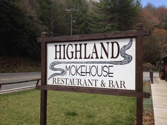
This is where we go locally for BBQ. It's located at 595 Franklin Road. From Two Holt, drive across Mirror Lake and go to the stop sign. Turn left on Franklin Road. You will see Highlands Smokehouse on the left. For a menu: https://www.facebook.com/highlands.smokehouse/app_160363220729661
|
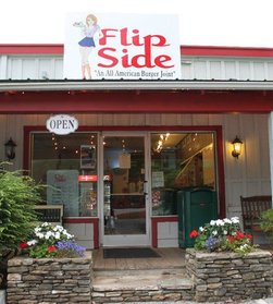
We've enjoyed a few burgers at this little place on the Dillard Road (across from the post office).
For a menu: http://highlandsrestaurantgroup.net/?page_id=26
|

If you drive down Main Street and pass Old Edwards Inn, you will see Mountain Fresh Grocery. Inside, you will find a wonderful little grill/deli. In fact, this is Phil's favorite place to get a hamburger. They also offer a take-out dinner menu with a different special each night. We love the shrimp for two dinner offered each Friday night! But be advised...I usually have to call ahead early afternoon to reserve a pickup time for the dinner for two...they often sell out before dinner time. For breakfast, lunch, or dinner menus: http://www.mountainfreshgrocery.com/grill
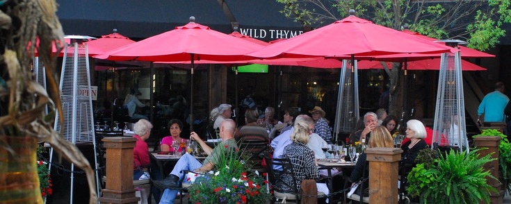
Wild Thyme is a great little restaurant on Main Street. Phil and I enjoyed shrimp salad there recently. Phil has also enjoyed the tomato basil soup and goat cheese salad with crusted pecans. Good food at a reasonable price. The menu can be found at http://wildthymegourmet.com/menu/ .
|
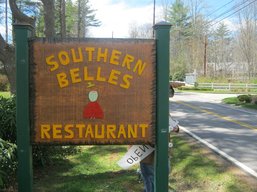
Located at 3601 Cashiers Road (Hwy 64 East), Southern Belles is usually a Sunday lunch place for us along with a few other of our church family. They are open each day for breakfast and lunch.
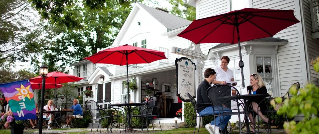
Indoor or outdoor dining--afternoon or evening at the Bistro on Main. This is part of the Main Street Inn. Phil had shrimp and grits which he deemed good, but not great. I had chicken pot pie which was good, but not great. I have heard others talk about how much they enjoy their lunch items. The outdoor atmosphere is lovely and usually there is someone playing the guitar and singing. The menu can be found at http://www.mainstreet-inn.com/bistro-hours-menu/bistro-on-main.htm.
|
